My Porfolio in Literature

Sunday, June 3, 2012

I. Isles of My Portfolio in Literature

Chapter 2 - Ilocos
 Chapter 3 - Cagayan Valley
Chapter 4 - Central Luzon
Chapter 5 - Southern Tagalog
Chapter 6 - Bicol
Chapter 7 - Western Visayas
Chapter 8 - Central Visayas
Chapter 9 - Eastern Visayas
Chapter 10 - Western Mindanao
Chapter 11 - Northern Mindanao
Chapter 12 - Southern Mindanaonao
Chapter 13 - Central Mindanao
Chapter 14 - Caraga
Chapter 15 - CAR - Cordillera Administrative Region
 Literature as a Platform in Education for Sustainable Development
IV. Reflection in Literature
V. Integration of Education for Sustainable Development to Literature

Thursday, May 24, 2012

Chapter 1 - Introduction to the Study of Phillippine Literature


Philippine literature is the literature associated with the Philippines and includes the legends of prehistory, and the colonial legacy of the Philippines. Most of the notable literature of the Philippines was written during the Spanish period and the first half of the 20th century in Spanish language. Philippine literature is written in Spanish, English, Tagalog, and/or other native Philippine languages.       

Philippine Literature is a diverse and rich group of works that has evolved side by side with the country’s history. Literature has started with fables and legends made by the ancient Filipinos long before the arrival of the Spanish influence. The main themes of Philippine literature focus on the country’s pre-colonial cultural traditions and the socio-political histories of its colonial and contemporary traditions.
It is not a secret that many Filipinos are unfamiliar with Philippine literature especially those written long before the Spanish arrived in our country. This is due to the fact that the stories of ancient time were not written, but rather passed on from generation to generation through word of mouth. Only in 1521 did the Filipinos become to be acquainted with literature due to the influence of the Spaniards on us. But the literature that the Filipinos became acquainted with are not Filipino made, rather, they were works of Spanish authors.
So successful were the efforts of colonialists to blot out the memory of the country's largely oral past that present-day Filipino writers, artists and journalists are trying to correct this inequity by recognizing the country's wealth of ethnic traditions and disseminating them in schools and through mass media.
The rise of nationalistic pride in the 1960s and 1970s also helped bring about this change of attitude among a new breed of Filipinos concerned about the "Filipino identity."

Chapter 2 - Ilocos


Ang Ilocos Rehiyong sa Pilipinas, tinatawag ding Rehiyon I, ay matatagpuan sa hilagang-kanlurang bahagi ng Luzon. Ang Rehiyong Administratibo ng Cordillera at Lambak ng Cagayan ang hangganan nito sa silangan, Gitnang Luzon sa timog, at Dagat Timog Tsina sa kanluran.

Ilocos collectively refers to two provinces in the Philippines: Ilocos Norte and Ilocos Sur. Inhabitants are called Ilocanos and they speak the language Iloko, also called Ilocano.
The Ilocos Region, containing four provinces, is named after Ilocos. 28% of the inhabitants of the region are Pangasinan people, who belong to a different ethnolinguistic group from the Ilocanos.
In the 330 pages “The Ilocos Heritage” (the 27th book written by Visitacion de la Torre), the Ilocano legacy and the life of the Ilocano – are described as - "the browbeaten, industrious, cheerful, simple soul who has shown a remarkable strain of bravery and a bit of wanderlust." The Ilocano history reveals his struggles and victories – in battles for colonial independence from Spain and America, to Philippine leadership. The new Ilocano searched for greener pastures towards new lands local and foreign - Palawan, Mindanao, Hawaii, the United States and Greece. The Ilocano material culture and spirituality can be seen in the past - images of Spanish santo (saints), antique but intricate wooden furniture and quality local fiber. The native Ilocano is a weaver, wood carver and pottery expert. The Ilocano cuisine – ranges from the exotic "abu-os" (ant eggs) to vegetable broth "dinengdeng," the sticky "tinubong" to the "poqui-poqui" (eggplant salad). Ilocandia is filled with colonial churches, the legacy of Spanish Catholicism.[1]

Chapter 3 - Cagayan Valley

Cagayan Valley (Lambak ng Cagayan in Filipino; Tana' nak Cagayan in the Ibanag Language; Tanap ti Cagayan in the Ilocano Language)(Ga-dang yoh Cagayan in Malaueg language) is a region of the Philippines, also designated as Region II or Region 02. It is composed of five provinces, namely: Batanes, Cagayan, Isabela, Nueva Vizcaya, and Quirino. It has three cities; Industrial center-Cauayan City, its regional center-Tuguegarao, and its commercial center-Santiago City.
Most of the region lies in a large valley in northeastern Luzon, between the Cordilleras and the Sierra MadreCagayan River, the country's longest river runs through its center and flows out to Luzon Strait in the north, in the town of Aparri, Cagayan. The Babuyan and Batanes island groups that lie in the Luzon Strait also belong to the region. mountain ranges. The

People, Culture and the Arts Due to the influx of Ilokano migrants in the last century, majority of the people of Cagayan speak Iloko as their primary tongue. Aside from the Ilokanos, there are several smaller ethnic groups that live in the province. The Ibanags are the dominant ethnic group in the vicinity of the provincial capital of Cagayan-—Tuguegarao, now a city. The closely related Itawits inhabit the Pinacanauan River valley as well as areas of Amulung and Tuao. The Malawegs are found mainly in the municipality of Rizal. In the foothills and the mountains of the Sierra Madre Range, several Negrito groups called the Agtas forage and hunt for food. The established lingua franca of the province is Ibanag.
The Ibanags, Itawits and Malawegs are mainly lowland farmers whose agricultural practices are similar to those of the Ilokanos. The Ibanags used to inhabit the area along the Cagayan coast but migrated further inland. They conducted trade with neighboring areas using distinctive seacrafts, and their commercial interests made their language the medium of commerce throughout the region before the influx of Ilokano migrants. They are also excellent blacksmiths and continue to make good bolos. The Ibanags are reputed to be the tallest of all the ethno-linguistic groups in the Philippines.
The Itawits are almost indistinguishable from the Ibanags. They build their houses with separate kitchens, connected by a narrow walkway that is used as washing area for hands and feet. The Itawits are noted for their pottery and basket-weaving traditions.
The culture of Cagayan is showcased in museums, historical buildings and archeological sites spread across the province. In Solana, the Neolithic archeological sites in Lanna have yielded stone tools used as early as 20,000 years back. The Cabarruan jar burial site, also in the town, features ancient Filipino traditions of taking care of their dead. The Cagayan Museum is a repository of the province´s cultural heritage. Iron Age pottery, Chinese Ming and Sung dynasty porcelain pieces as well as Church paraphernalia are on display together with Paleolithic fossils. The oldest bell in the country, cast in 1592, still peals from the tower of the church in Camalaniugan. The old brick works in Tuguegarao lie inside the city and speak of a time when bricks were extensively used to build the beautiful churches of the Cagayan Valley.

Chapter 4 - Central Luzon


Alamat ng Bundok Pinatubo

Alamat ng Luzon Masagana ang Kahariang Masinlok. Magandang maganda noon ang umaga. Maningning ang sikat ng araw. Sariwa ang hanging amihan. Lunti ang mga halaman sa paligid. Masigla ang awit ng mga ibon. Bughaw ang kabundukan. Subalit ang kagandahan ng umaga ay hindi nakasiya sa Datu. Wala siyang madamang kaligayahan sa lahat ng namamalas. Malungkot [...]


Central Luzon

(or Gitnang Luzon in Filipino) , also known as Region III (or Region 3), is an administrative division or region of the Republic of the Philippines, primarily serve to organize the 7 provinces of the vast central plain of the island of Luzon (the largest island), for administrative convenience. The region contains the largest plain in the country and produces most of the country's rice supply, earning itself the nickname "Rice Bowl of the Philippines". Its provinces are: Aurora, Bataan, Bulacan, Nueva Ecija, Pampanga, Tarlac, and Zambales.
Central Luzon Region is located north of Manila, the nation's capital. Bordering the region are the regions of Ilocos, Cordillera Administrative Region and Cagayan Valley regions to the north; National Capital Region and CALABARZON to the south; and of waters of Manila Bay to the south; South China Sea to the west; and The Philippine Sea to the east.
There are thirteen cities which include: Balanga in Bataan; Malolos, Meycauayan and San Jose del Monte in Bulacan; Cabanatuan, Gapan, Muñoz, Palayan and San Jose in Nueva Ecija; Angeles and San Fernando in Pampanga; Tarlac in Tarlac; and Olongapo in Zambales.Central Luzon produces the most rice in the whole country.Excess rice is delivered and imported to other provinces of the Philippines.

Chapter 5 - Southern Tagalog


Southern Tagalog

or Region IV, was a region of the Philippines that is now composed of Region IV-A (CALABARZON) and Region IV-B (MIMAROPA). Region IV was split into the two regions on May 17, 2002. Before the split, Southern Tagalog was the largest region in terms of both population and area.

Southern Tagalog comprises the provinces of Aurora, Batangas, Cavite, Laguna, Marinduque, Oriental Mindoro, Occidental Mindoro, Quezon, Rizal, Romblon, and Palawan. Quezon City was the designated regional center of Southern Tagalog. Southern Tagalog covers the area where many Tagalog native speakers reside. The new capital region also known as NCR of Metro Manila and Central Luzon are the other regions of native Tagalog speakers.
By virtue Executive Order No. 103, dated May 17, 2002, Region IV was divided into Region IV-A (CALABARZON) and Region IV-B (MIMAROPA).


Chapter 6 - Bicol


Mayon Volcano, also known as Mount Mayon, is an active volcano in the province of Albay, on the island of Luzon in the Philippines. Renowned as the "perfect cone" because of its almost symmetric conical shape, Mayon forms the northern boundary of Legazpi City, the largest city in terms of population in the Bicol Region. The mountain is a national park and a protected landscape in the country proclaimed as Mayon Volcano Natural Park in the year 2000.[3]
Local folklore refers to the volcano as Bulkang Magayon (Bikol: 'Beautiful Volcano'), after the legendary heroine Daragang Magayon (Bikol


Chapter 7 - Western Visayas


Panay Island

Panay is an island belonging to Western Visayas (Region VI) in central Philippines. It is divided into 4 provinces namely Aklan, Antique, Capiz and Iloilo. Panay has a total land area of 11, 692.50 km2.
Its boundaries are the Visayan Sea on the east, the Cuyo East Pass on the west, the Sibuyan sea and the province of Romblon on the north; Sulu Sea on the southwest and Guimaras Strait on the south.
The topography of Panay is characterized by relatively wide stretch of coastal lowlands with rugged hills and mountains on the interiors. There are no volcanos on Panay Island.
 
Western Visayas, one of the regions of the Philippines, is designated as Region VI. It consists of six provinces; Aklan, Antique, Negros Occidental, Capiz, Guimaras and Iloilo and 16 cities making it the region with the highest number of cities. Iloilo City is the regional center.[1]
Western Visayas is composed of six provinces and the highly urbanized cities of Bacolod and Iloilo.

Chapter 8 - Central Visayas


The Chocolate Hills is an unusual geological formation in Bohol Province, Philippines.[1] There are at least 1,260 hills but there may be as many as 1,776 hills spread over an area of more than 50 square kilometres (20 sq mi).[2] They are covered in green grass that turns brown during the dry season, hence the name.
The Chocolate Hills is a famous tourist attraction of Bohol. They are featured in the provincial flag and seal to symbolize the abundance of natural attractions in the province.[3] They are in the Philippine Tourism Authority's list of tourist destinations in the Philippines;[4] they have been declared the country's third National Geological Monument and proposed for inclusion in the UNESCO World Heritage List.


Four legends explain the formation of the Chocolate Hills. The first tells the story of two feuding giants who hurled rocks, boulders, and sand at each other. The fighting lasted for days, and exhausted the two giants. In their exhaustion, they forgot about their feud and became friends, but when they left they forgot to clean up the mess they had made during their battle, hence the Chocolate Hills.[13][17]
A more romantic legend tells of a giant named Arogo who was extremely powerful and youthful. Arogo fell in love with Aloya, who was a simple mortal. Aloya's death caused Arogo much pain and misery, and in his sorrow he could not stop crying. When his tears dried, the Chocolate Hills were formed.[18]
The third legend tells of a town being plagued by a giant carabao, who ate all of their crops. Finally having had enough, the townsfolk took all of their spoiled food and placed it in such a way that the carabao would not miss it. Sure enough, the carabao ate it, but his stomach couldn't handle the spoiled food, so he defecated, leaving behind him a mound of feces, until he had emptied his stomach of the food. The feces then dried, forming the Chocolate Hills.
The last legend is about a gluttonous giant named Miguel that eats everything in his path. One day he came to a plain. He saw a beautiful young woman named Adrianna. To win her affection, he needed to lose weight. So he excreted everything he ate. In the end, his fecal matter covered the land and he won Eng's affection.


Chapter 9 - Eastern Visayas


Eastern Visayas
 
is one of the two regions of the Philippines having no land border with another region, MIMAROPA being the other, and is designated as Region VIII. It consists of six provinces and seven cities, namely, Biliran, Eastern Samar, Leyte, Northern Samar, Samar, Southern Leyte, the cities of Ormoc City, Baybay City, Maasin City, Calbayog City, Catbalogan City, Borongan City and the highly-urbanized city of Tacloban, the regional center. These provinces and cities occupy the easternmost islands of Visayas: Samar, Leyte and Biliran.
Eastern Visayas directly faces the Pacific Ocean. The land area of the region is 23,432 km km². As of 2007, it has a population of 3,912,936.


Chapter 10 - Western Mindanao


Mindanao 

Is the second largest and easternmost island in the Philippines. It is also the name of one of the three island groups in the country, which consists of the island of Mindanao and smaller surrounding islands. The other two are Luzon and the Visayas. The island of Mindanao is called The Land of Promise. Mindanao is the only area of the Philippines with a significant Muslim presence.
Mindanao has been the site of a separatist movement by the Moro Islamic Liberation Front (MILF), caused by religious differences and widespread poverty. Fighting between MILF and Philippine forces has displaced over 100,000 people, and the conflict has brought in Islamic extremism.

Chapter 11 - Northern Mindanao


Northern Mindanao 
Designated as Region X of the Philippines, Northern Mindanao (Filipino: Hilagang Mindanao) is composed of five provinces and two cities classified as highly-urbanized, all occupying the north-central part of Mindanao island, and the island-province of Camiguin. The regional center is Cagayan de Oro City, where the national government's regional offices and other big establishments are located. Lanao del Norte was transferred to Northern Mindanao from Region XII (then called Central Mindanao).


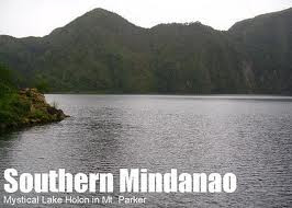
Chapter 12 - Southern Mindanao


Davao Region / Southern Mindanao,

 designated as Region XI, is one of the regions of the Philippines, located on the southeastern portion of Mindanao. Davao Region consists of four provinces, namely: Compostela Valley, Davao del Norte, Davao Oriental, and Davao del Sur. The region encloses the Davao Gulf and its regional center is Davao City. Davao is the Hispanicized pronunciation of daba-daba, the Bagobo word for "fire" (the Cebuano translation is "kalayo"). 

Many historians believe that the name "Davao" is actually the mixture of the three names that three different tribes, the earliest settlers in the region, had for the Davao River. The Obos, an aboriginal tribe, referred to the Davao River as Davohoho. Another tribe, the Bagobos, referred to the river as Davohaha, which means "fire", while another tribe, the Guiangan tribe, called the river as Duhwow.
The history of the region dates back to the times when various tribes occupied the region. It is believed that the Manobos, Mandayas and the Bagobos actually occupied the area. These are the same tribes that created the small settlements and communities that eventually became Mindanao.

Chapter 13 - Central Mindanao


CENTRAL MINDANAO/SOCCSKSARGEN


Is a region of the Philippines, located in central Mindanao, and is officially designated as Region XII. The name is an acronym that stands for the region's four provinces and one of its cities: South Cotabato, Cotabato, Sultan Kudarat, Sarangani and General Santos City. The regional center is Koronadal City located in the province of South Cotabato.[2] Cotabato City, though geographically within the boundaries of the province of Maguindanao, itself is part of SOCCSKSARGEN, and is independent of that province. Maguindanao province is, in fact, a part of the Autonomous Region in Muslim Mindanao (ARMM) which has its seat in Cotabato City. SOCCSKSARGEN and the province of Maguindanao were once part of the original Cotabato province. 
SoCCSKSarGen is a region of the Philippines, located in central Mindanao, and is officially designated as Region XII. The name is an acronym that stands for the region's four provinces and one of its cities: South Cotabato, Cotabato, Sultan Kudarat, Sarangani and General Santos City. Cotabato City itself is part of SOCCSKSARGEN, but Maguindanao is part of the Autonomous Region in Muslim Mindanao. (Datu Paglas is part of Maguindanao, but since we passed it along the way, I have included images as well).

Chapter 14 - Caraga

Ang Caraga ay isang rehiyon ng Pilipinas na matatagpuan sa hilagang silangang bahagi ng pulo ng Mindanao. Nabuo ito sa bisa ng Republic Act No. 7901 noong Pebrero 23, 1995 na inaprubahan ni Pangulong Fidel V. Ramos. Ang Rehiyon ay binubuo ng lima (5) na lalawigan: Agusan del Norte, Agusan del Sur, Surigao del Norte, Surigao del Sur at Dinagat Islands; tatlong (3) lungsod: Butuan, Surigao at Bislig; pitumpong (70) bayan at 1,346 na barangay. Ang Lungsod ng Butuan ang Sentrong Pang-Rehiyon.


TRAHEDYA NG ISANG BIRHEN
by Genevieve Asenjo
walang dugong
umagos sa aking
mga hita sa unang gabi
ng kanyang paglusob.

umalingawngaw sabay
sa kanyang paglusong-
ahon ang mga hiyaw
ko't daing: sakit, hapdi,
pamamaga
ngunit nilunod ng kanyang
pagdududa ang kabanalan
ng aking kawalang-malay,
ala-Othello siyang naging taga-
hukom ng aking pagkababae:
birhen o puta?

walang dugong
umagos mula
sa aking hita.
lumabas ito sa bunganga
ko't sumalo sa nanunuyong
mga pawis at luha.

Chapter 15 - CAR - Cordillera Administrative Region

 The Boy Who Became a Stone 

A Tinguian Folklore

One day a little boy named Elonen sat out in the yard making a bird snare, and as he worked, a little bird called to him:
“Tik-tik-lo-den” (come and catch me).
“I am making a snare for you,” said the boy; but the bird continued to call until the snare was finished.
Then Elonen ran and threw the snare over the bird and caught it, and he put it other boys to swim.
While he was away, his grandmother grew hungry, so she ate the bird, and when Elonen returned and found that his bird was gone, he was so sad that he wished he might go away and never come back.

He went out into the forest and walked a long distance, until finally he came to a big stone and said:
“Stone, open your mouth and eat me.” And the stone opened its mouth and boy.
When his grandmother missed the boy, she went out and looked everywhere, hoping to find him. Finally she passed near the stone and it cried out:
“Here he is.”
Then the old woman tried to open the stone but she could not, so she called the horses to come and help her. They came and kicked it, but it would not break.
Then she called the carabao and they hooked it, but they only broke their horns. She called the chickens, which pecked it, and the thunder, which shook it, but nothing could open it, and she had to go home without the boy.

Chapter 16 - ARMM - Autonomous Region of Muslim Mindanao


  • The Maguindanao, literally, "people of the flood plains", occupy the basin of the Pulangi River.  The southern fork of the river flows towards Illana Bay.  In the past the Maguindanao settled along the banks and in the valley regions of the river.  Today they are found in several provinces.  In Maguindanao province, which accounts for 76% of the total Maguindanao population, they are settled in Barira, Buldon, Parang, Sultan Kudarat, Kabuntalan, Dindig, North Upi, Matanog, Cotabato City, Buluan, Datu Panglas, Pagalungan, Ampatuan, Maganoy, Datu Piang, Talayan, Sultan sa Barongis, General Salipada Pendatun, and South Upi.  In Cotabato province, they are found in Pikit and Kabacan.  In Sultan Kudarat province, they live in Lebak, Palembang, and Kalamansig, all coastal towns.  In 1988 the Maguindanao population numbered approximately 500,000 (Peralta 1988:7).

            The Maguindanao language is part of a subgroup of languages called the "Danao languages".  The subgroup includes Maranao, spoken in the Lanao provinces; Ilanun (also Ilanum or Iranun), spoken by a group of sea-based people between Lanao and Maguindanao;  and Maguindanao, mainly spoken in Maguindanao, Cotabato, and Sultan Kudarat (McFarland 1983:96).


Chapter 17- NCR - National Capital Regoin

Metro Manila

Ang Lungsod Maynila ay ang kabesera ng Pilipinas at isa sa mga lungsod na bumubuo sa Kalakhang Maynila. Ang Maynila ay matatagpuan sa silangang baybayin ng Look Maynila sa Luzon.
Ang Maynila ang sentro ng gawain ng 10 milyong katao. Ang Kalakhang Maynila ay kilala bilang National Capital Region. Ang Lungsod Maynila ay mataong lugar na may bilang na 1.5 milyong katao at ikalawa sa Lungsod Quezon na may pinakamadaming bilang ng populasyon at dating kabesera ng Pilipinas.
Ang Maynila ay puno ng mga atraksyon tulad ng Luneta Park, Manila Bay at iba pa. Dito rin matatagpuan ang Unibersidad ng Santo Tomas na siyang pinakamatandang unibersidad sa Pilipinas na itinayo noong 1611 ng mga prayleng Espanol.
Ang Intramuros, na nasa Maynila, noon ang nag silbing "Mini-Spain" ng Pilipinas dahil lahat ng naninirahan doon ay pawang mga Kastila lamang. Dito matatagpuan ang St. Augustine Church na kung saan matatagpuan ang pinakaunang "bamboo organ".

Metropolitan Manila (Filipino: Kalakhang Maynila) or the National Capital Region (NCR) (Filipino: Pambansang Punong Rehiyon) is the capital of the Philippines and among the world's thirty most populous metropolitan areas. Metro Manila is one of the two defined metropolitan areas in the Philippines, the other being Metro Cebu.
Metro Manila is the metropolitan area that contains the city of Manila, as well as sixteen surrounding cities and municipalities, including Quezon City, the capital from 1948 to 1976. Metro Manila is the political, economic, social, and cultural center of the Philippines, and is one of the more modern metropolises in Southeast Asia. Among locals, particularly those from Manila proper and those in the provinces, Metro Manila is often simply referred to as Manila; however locals from other parts of the metropolis may see this as offensive, owing to city pride and also the fact that some cities are actually geographically closer to the neighboring provinces than to Manila itself. Metro Manila is often abbreviated as M.M.. The Metropolitan Manila Development Authority (MMDA) is located in Makati City.
Metro Manila is the smallest of the country's administrative regions, but the most populous and the most densely populated, having a population of 9,932,560 (2000 census) in an area of only 636 square kilometers. It is also the only region without any provinces. The region is bordered by the provinces of Bulacan to the north, Rizal to the east, and Cavite and Laguna to the south. Metro Manila is also sandwiched by Manila Bay to the west and Laguna de Bay to the southeast with the Pasig River running between them, bisecting the region.
The term Metro Manila should not be confused with the metro rail system of the region, and the word metro itself always describes the metropolitan area (as in the metro). The railways are called by their abbreviations, such as the LRT and the MRT, also known as Light Rail Transit and Metro Rail Transit, respectively.
On paper, Manila is the designated capital and seat of the Philippine government, but in practice, the seats of government are all around Metro Manila. The executive and administrative seat of government is located in Manila, so is the judiciary. The upper house of the legislature (Senate of the Philippines) is located in Pasay City, and the lower house (House of Representatives of the Philippines) in Quezon City.

II. Students Outputs of E- Portfolio

1. Apiado, Vina Mae
2. Gabor, Pinky Mae
3. Soria, Mark
4. Sumulong, Jason
5. Luig, Ian
6. Traje, Lemuel
7. Ramolete, Marcos
8. Sibag, Marites
9. Dayon, Sybelle Ann
10. Castaneda, Grizzly
11. Castaneda, Mylene
12. Bismar, Kyrien Kaye
13. Iwag, Cristine Joy
14. Tamesis, Aster Ivy
15. Tamonda, Cassandra

16. Fernandez, Desiree
17. Armonio, Jaysar
18. Tabilla, Charish
19. Ballares, Charlene
20. Abarro, Rina
21. Eliarda, Elieyzah Jhane
22. Vinluan, Felamae
23.  Macailing, Geosalyn
24. Rivera, Dianne Rose
25. Galenzoga, Sheena
26. Jimenea, Monette
27. Collantes, Maybelyn
28. Tano, Shiela Mae

29. Orbigo,  Shena
30. Iglesias, Melanie
31. Lopez, Grace
32. Mamparo, Merry Chris